Wednesday, October 13, 2010

Race in Rochester

Today I came across a very interesting series of maps created by Eric Fischer. He used 2000 census data to map major US cities by race. What was striking was the level of segregation that persists is nearly all American cities today. Here is what Rochester's racial map looks like:


The red dots represent whites, the blue dots are blacks, orange are hispanics, and green are asians. Each dot represents 25 people. You can look at racial maps for other US cities here.

Wednesday, August 25, 2010

Meet me in St Louis

My time in Rochester has come to an end. Sadly I have to leave our fair city to finish college. I will still use this blog to comment on development issues in Rochester, but it will be from a distant perspective. For those of you who have enjoyed my work here I am starting a new blog Quaint Louis to talk about development in the Arch City. I'll be sure to bring a little Roc to the Lou:


Thursday, August 12, 2010

The next High Falls/Corn Hill/Southwedge etc.

The new urbanization trend is alive and well in Rochester. Downtown has a residential vacancy rate below 4%; there simply is not enough housing downtown to meet demand. As up and coming neighborhoods like the Southwedge mature, urban pioneers will be looking for the next edgy neighborhood to inhabit. Here are two areas bordering downtown that have the gritty urban feel and majestic warehouses that invite the new class of urban dwellers. All they need is a little love and a lot of investment and they could become the next trendy neighborhoods. 

THE CANAL DISTRICT


Situated between the Cascade District of downtown and the historic Susan B. Anthony neighborhood, the Canal District was once an industrial area. Today its warehouses appear abandoned but some operations like Volunteers of America and Neal Barret Woodworking have moved in. Converting these warehouses into lofts, new construction to fill vacant lots, and new streets could really transform this sleeping giant next to downtown:

Canal District Today
Future Canal District. Light blue areas are for new construction, dark blue are existing buildings.

THE BOTTLE DISTRICT


This area sandwiched between the Genesee Brewery and the Coca-Cola bottling plant is a much less stable part of town than the Canal District, but its marketing potential is far more interesting. There are many great warehouses along St. Paul St that are begging for residential conversion. The proximity to the falls is a significant asset for the area. The brewery has tours but I dont think the Coke plant does; if it did that would make two big draws to the area. Add some microbreweries, pubs, and an olde tyme soda parlor and you've turned the neighborhood into a real destination. 

Bottle District Today
Future Bottle District. Light blue areas are for new construction, dark blue are existing buildings.

Wednesday, August 11, 2010

Hot development sites for post-recession Rochester

Despite the recession, downtown is experiencing a development renaissance. Over $700 million are invested in projects downtown. This number would be much higher if the recession did not take several projects out of the development pipeline. As the economy recovers it will become easier for developers to access credit to finance these projects. Rochester made national headlines as one of the few cities that endured the recession relatively unscathed. This reputation should attract capital from large banks looking for a secure market to invest in. When credit markets do open up, here are the hot development sites that will likely see the first dollars:

BLOCK F
Probably the hottest development site in the city outside of Midtown. This site has had many proposals but has faced opposition from Grove Place neighbors who want the development to blend with the neighborhood. Its location in the heart of the Eastman School campus makes the land very valuable.


 FRONT ST
This brownfield site is all that remains of Rochester's famed Front St. Despite clean-up costs its prime location on the river and in between popular St Paul and High Falls neighborhoods make it very valuable.

EXCHANGE & COURT
Another riverfront property, this parking lot currently hosts the city's concert series 'Party in the Park'. This site is next to Blue Cross Arena and Corn Hill Landing.


67 CHESTNUT
This ugly white building drastically increased in value ever since the redevelopment of Midtown was announced. Behind its sterile facade the building may have good bones. 

Thursday, August 5, 2010

D&C unveils three potential sites for MCC Damon campus

In last Friday's edition of the Democrat and Chronicle three potential sites for MCC's new downtown campus were unveiled. The article predates an official announcement from MCC. Here are the sites listed in the D&C:

1. Kodak's 7+ acre parking lot in high falls
2. Three Parcels on the Midtown site
3. St. Joseph's Park

I find it hard to believe that MCC was giving any serious consideration to the Kodak site because there hasn't been any dialog between the company and the college. MCC wants their downtown campus to be in the middle of downtown, and high falls is a little to far from the center for the Kodak site to be in the top of MCC's list.

Midtown would be a great place for MCC to go if the were aiming for the RBTL theater site. The other parcels listed in the D&C don't fit as well--parcels A and C flank either side of Midtown tower where high end apartments and condos will be. Parcel B is in the butt of the Cadillac hotel. That whole side of the midtown site seems better suited for office or hotel space than a community college.

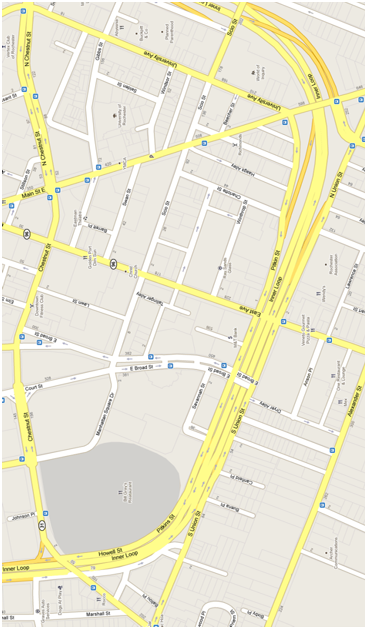
The St. Joseph's Park site seems like the best of the three sites. It's a little farther off the beaten path than the midtown site, but its between the St Paul Quarter, East End/Eastman, and Main St. It will also be close to the new transit center at Mortimer St. The St. Joseph neighborhood is a blank slate because it lacks a concrete identity beyond the relic of an old church facade. MCC could redefine the neighborhood as an urban college town and spur new development around it. I see a bright future for MCC at this site:

Friday, July 30, 2010

Inner Loop reconstruction


The days of the Inner Loop may be numbered. In a few years the bridges over the loop need to be replaced, and the city plans on telling the state to use the money for bridge repair to fill in the eastern portion of the loop instead. This portion from Main St. to I-490 is the least traveled. The state, which is responsible for maintaining the road, will actually save money in the long run through lower maintenance costs.

There is one thing about the Inner Loop that I think needs to be preserved. When I was just getting acquainted with downtown the street system was very confusing to me. Despite this I was confident driving around downtown—I knew how matter how lost I got all I had to do was keep going straight and I would hit the Inner Loop. If the Inner Loop truly disappears, so does its ability to orient drivers and pedestrians. I suggest it still be signed ‘Inner Loop’ to keep its identity as loop around town, but add ‘Boulevard’ to instill its new identity as a pedestrian friendly street. If the street retains its route 940T (Inner Loop) designation it will continue to be maintained by NYDOT funds instead of local taxes.

I have seen some of the plans for the new street grid and I wasn’t satisfied. They featured round-abouts that can be confusing for drivers and therefore dangerous for pedestrians. The ideal redesign for the loop would have the following features:
-One way streets eliminated
-Restored alignment of University Ave and neighborhood streets
-Park Ave connected to Manhattan Sq Park pedestrian mall

Here is what the eastern portion of the Inner Loop looks like today along side my redesign of the Loop. The green spaces are parcels of land freed up by the removal of the expressway or other street alterations.

Thursday, July 22, 2010

Proposed skate park for downtown

A few weeks ago I noticed metal brackets appear around the building I work to keep skateboarders off. It got me wondering if there was a place for skateboarding in Rochester. Today I found out about Roc City Park, a proposed skate park off South Ave under the Freddie Sue aka Fredrick Douglas Susan B Anthony Memorial Bridge. I was surprised to find the proposal has approval from the city and is in the process of raising $500,000 to begin construction. Here is a rendering of the park I found on its website roccitypark.com:


I am very excited to know that the city is behind incorporating the skating community into downtown. The park will do a good job bridging the gap between downtown and the popular Southwedge neighborhood.

Wednesday, July 21, 2010

Demolition/Construction schedule for Midtown

Yesterday city hall announced the demolition and construction schedule for the midtown site:


We will begin to see street and sidewalk closings and the arrival of construction vehicles on August 1st. By mid August they will have removed a significant chunk of the B. Forman building.

Midtown Phases

The city has an important decision to make by September 1st--whether or not to keep the skeletons of two alternate structures. The only two structures that are guaranteed to be recycled are the Midtown tower which will be converted into condos and apartments, and the Seneca building which will make up the bulk of PAETEC's new headquarters. The alternates are buildings which have the potential to be recycled as well, but lack commitments from private sector companies for reuse. The steel superstructures are valuable due to the rising price of steel and would save potential redevelopers time and money. If the city delays the decision on these structures beyond August 1st they will be charged a fee from their contractors.

Buildings that will remain after the demolition

Tuesday, July 20, 2010

Tying Broad St in with the East End


Broad St is designated as the southern border of the East End neighborhood within the Inner Loop. As far as borders go it is excellent--its six lanes are quite daunting for pedestrians to cross. I use the street everyday to get to and from work, but I rarely see more than two other cars using the street. I assume Broad Street's current design originates from the Inner Loop era when city officials feared downtown would fall victim of traffic congestion. The street is a main east-west arterials in the city, but few people actually use its eastern end. This is probably because few people use the eastern portion of the Inner Loop (which the city just completed a study to fill in). Because the street was designed to quickly move high volumes of traffic in and out of the city, the streetscape on Broad St is just like that of a highway--completely void of retail or pedestrian traffic.

To bring life back into this forgotten part of the East End neighborhood, Broad St must be redesigned. The city is planning a round-about for the intersection of Broad and Broadway. I have looked at these plans and I dont believe they will do much of anything to improve the streetscape on Broad St. I believe the solution to a dead Broad St lies in changing it from a six lane divided highway (like 590) into a two lane road with street side parking (like East Ave). Here is what I imagined for Broad St:

Broad St is one of the few streets that has a bridge over the Inner Loop. Instead of having the street dead end on the portion of the loop that is sparsely used, it could be carried along Dryer Alley  to Alexander St. This connection would bring new life--pedestrian and auto traffic--to the street. Not only is resizing Broad St to two traffic lanes more appropriate for the volume the street carries, but it also is more pedestrian friendly. The land that would be freed up from downsizing the street can be used for building new street level retail operations:

Developable parcels along a right-sized Broad St

Monday, July 19, 2010

My rebranding proposal for Main & Clinton neighborhood

Main & Clinton

The Main & Clinton neighborhood is the center of downtown Rochester. For decades it was the heart of retail in Rochester. Today the Main & Clinton neighborhood is fundamentally different from how it existed for the past half century. This neighborhood needs to be rebranded to reflect these fundamental changes and keep its momentum moving in a positive direction.


Proposed block-busting
Main & Clinton is 4 superblocks
At midcentury Main & Clinton was a thriving retail center and an example to cities across the country. The Sibley building was home to the largest department store between New York and Chicago; Midtown Plaza was the nation’s first downtown indoor mall and was believed to be the solution to the midcentury urban crisis. The new urban crisis—depopulation and urban sprawl—made the retail giants of the past unsustainable. The massive structures they created became awkward homes to smaller tenants who wished to capitalize on the central location of Main & Clinton. Sadly these structures have fallen into disrepair after years of disinvestment by building owners. The superblock streetscape is unfriendly to pedestrian traffic. The open air bus terminal is the only thing that brings people onto the streets. Without it the neighborhood would appear entirely devoid of life.


Residential conversion of Midtown Tower
Today over 75% of the neighborhood is ‘development sites’. Midtown Plaza which closed in 2008 is undergoing demolition and will be subdivided into several smaller parcels. The Sibley building may lose its primary tenant when MCC announces the location for its new downtown campus. The Renaissance Square project died in 2009 but it remains a dormant development site and many of its buildings are owned by the county. The open air bus transfer function that has operated along Main St appears to be leaving the neighborhood with City Council’s 2010 approval for the abandonment of Mortimer St.
PAETEC headquarters rendering


The Main & Clinton neighborhood has hit bottom of a long and painful decline. The neighborhood now stands in a transitional phase where the development strategies employed today will define the character of the neighborhood for decades to come. Rebranding the neighborhood will add to the energy and excitement of the area and keep the development momentum strong.

Three of downtown’s neighborhoods are named for their public spaces. Public spaces are defining for the neighborhoods that surround them because they serve as a community gathering space and are flexible in their utility. A new public space is planned for the midtown block that has the potential to redefine the Main & Clinton neighborhood. Renaming the neighborhood after the new space could focus perceptions of the neighborhood away from declining entities like Sibley’s and the Ren Square block and on the positive developments of the midtown block.

Tuesday, June 15, 2010

Two projects downtown move forward

Today at noon the Rochester Broadway Theater League made their announcement to move forward with plans for a new theater downtown. The theater will occupy a parcel of the midtown development block that once was home to McCurdy's department store. The project is expected to cost $70 million.

At this evening's city council meeting, city council approved the proposal to abandon Mortimer St. to make way for a new transit center. The new center will replace the open air bus terminal that stretches along Main St. from the Liberty Pole to St. Paul. The center will capitalize on $52 million in state and federal transportation funds slated for the defunct  Renaissance Square project.

Although both projects are not without drawbacks, I believe they will help spur further development along Main St. and will have significant effects on the Sibley building and the Midtown development block. The presence of cranes downtown will energize this city and demonstrate that we are moving forward.

Friday, June 4, 2010

Downtown Surface Parking

Surface parking lots are colored pink
A recent survey of downtown workers found inconvenient parking as a deterrent for spending leisure time downtown. This map shows the surface parking lots located in downtown not including parking garages. Given the vast acreage of parking lots that downtown already has, Rochester should look for an alternative solution to its parking problem. More parking garages will help with the quantity of parking spaces but are limited in their ability to help with parking convenience. Most of downtown's lots are on its periphery and most of the activity is in the center. A similar problem is faced by most college campuses; their solution is a shuttle bus system. Will this work for downtown? Maybe.

Monday, May 24, 2010

ESL Ribbon Cutting

I attended the ribbon cutting ceremony for the new ESL federal credit union headquarters last Thursday. Speeches were made by ESL's CEO Dave Fiedler, Mayor Robert Duffy, County Executive Maggie Brooks,  VP of City Council Elaine Spaull, and President of RDDC Heidi Zimmer-Meyer. The speakers focused on the teamwork that went into getting the project off the ground and the commitment it represented to the Rochester community. The building is a $58 million investment which brings 350 new workers downtown. Located across from the Strong National Museum of Play, the new headquarters acts as a gateway into downtown for traffic on Chestnut St.

Monday, May 10, 2010

My work on the growth of cities

In my econometrics class I modeled the growth of the fifty largest US cities. Sadly Rochester did not fall in that list (as of the US Census Bureau’s July 2008 report it is number 99). From my research I learned that the most important factors in determining a city's growth rate are: cost of living, median household income, foreign born population, crime density, daytime population, and education. I thought it would be interesting to see how Rochester compares to the cities I examined in my model. 

Rochester (comparison)

Growth Rate: -5.9% (49 Philadelphia, PA)
Cost of Living: 84.6 (40 Jacksonville, FL)
Median Household Income: $29,975 (48 Miami, FL)
Foreign Born Population: 7.3% (36 Nashville, TN)
Crime Density: 56.75 (17 Milwaukee, WI)
Daytime Population: +35.2% (5 Louisville, KY)
Higher Education: 28.1% (40 Baltimore, MD)