Friday, July 30, 2010

Inner Loop reconstruction


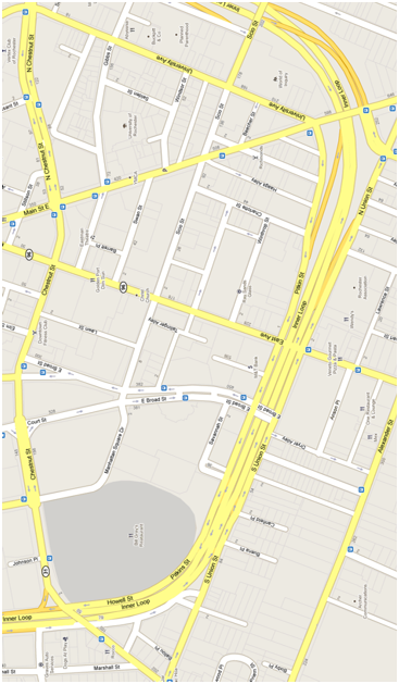
The days of the Inner Loop may be numbered. In a few years the bridges over the loop need to be replaced, and the city plans on telling the state to use the money for bridge repair to fill in the eastern portion of the loop instead. This portion from Main St. to I-490 is the least traveled. The state, which is responsible for maintaining the road, will actually save money in the long run through lower maintenance costs.

There is one thing about the Inner Loop that I think needs to be preserved. When I was just getting acquainted with downtown the street system was very confusing to me. Despite this I was confident driving around downtown—I knew how matter how lost I got all I had to do was keep going straight and I would hit the Inner Loop. If the Inner Loop truly disappears, so does its ability to orient drivers and pedestrians. I suggest it still be signed ‘Inner Loop’ to keep its identity as loop around town, but add ‘Boulevard’ to instill its new identity as a pedestrian friendly street. If the street retains its route 940T (Inner Loop) designation it will continue to be maintained by NYDOT funds instead of local taxes.

I have seen some of the plans for the new street grid and I wasn’t satisfied. They featured round-abouts that can be confusing for drivers and therefore dangerous for pedestrians. The ideal redesign for the loop would have the following features:
-One way streets eliminated
-Restored alignment of University Ave and neighborhood streets
-Park Ave connected to Manhattan Sq Park pedestrian mall

Here is what the eastern portion of the Inner Loop looks like today along side my redesign of the Loop. The green spaces are parcels of land freed up by the removal of the expressway or other street alterations.

Thursday, July 22, 2010

Proposed skate park for downtown

A few weeks ago I noticed metal brackets appear around the building I work to keep skateboarders off. It got me wondering if there was a place for skateboarding in Rochester. Today I found out about Roc City Park, a proposed skate park off South Ave under the Freddie Sue aka Fredrick Douglas Susan B Anthony Memorial Bridge. I was surprised to find the proposal has approval from the city and is in the process of raising $500,000 to begin construction. Here is a rendering of the park I found on its website roccitypark.com:


I am very excited to know that the city is behind incorporating the skating community into downtown. The park will do a good job bridging the gap between downtown and the popular Southwedge neighborhood.

Wednesday, July 21, 2010

Demolition/Construction schedule for Midtown

Yesterday city hall announced the demolition and construction schedule for the midtown site:


We will begin to see street and sidewalk closings and the arrival of construction vehicles on August 1st. By mid August they will have removed a significant chunk of the B. Forman building.

Midtown Phases

The city has an important decision to make by September 1st--whether or not to keep the skeletons of two alternate structures. The only two structures that are guaranteed to be recycled are the Midtown tower which will be converted into condos and apartments, and the Seneca building which will make up the bulk of PAETEC's new headquarters. The alternates are buildings which have the potential to be recycled as well, but lack commitments from private sector companies for reuse. The steel superstructures are valuable due to the rising price of steel and would save potential redevelopers time and money. If the city delays the decision on these structures beyond August 1st they will be charged a fee from their contractors.

Buildings that will remain after the demolition

Tuesday, July 20, 2010

Tying Broad St in with the East End


Broad St is designated as the southern border of the East End neighborhood within the Inner Loop. As far as borders go it is excellent--its six lanes are quite daunting for pedestrians to cross. I use the street everyday to get to and from work, but I rarely see more than two other cars using the street. I assume Broad Street's current design originates from the Inner Loop era when city officials feared downtown would fall victim of traffic congestion. The street is a main east-west arterials in the city, but few people actually use its eastern end. This is probably because few people use the eastern portion of the Inner Loop (which the city just completed a study to fill in). Because the street was designed to quickly move high volumes of traffic in and out of the city, the streetscape on Broad St is just like that of a highway--completely void of retail or pedestrian traffic.

To bring life back into this forgotten part of the East End neighborhood, Broad St must be redesigned. The city is planning a round-about for the intersection of Broad and Broadway. I have looked at these plans and I dont believe they will do much of anything to improve the streetscape on Broad St. I believe the solution to a dead Broad St lies in changing it from a six lane divided highway (like 590) into a two lane road with street side parking (like East Ave). Here is what I imagined for Broad St:

Broad St is one of the few streets that has a bridge over the Inner Loop. Instead of having the street dead end on the portion of the loop that is sparsely used, it could be carried along Dryer Alley  to Alexander St. This connection would bring new life--pedestrian and auto traffic--to the street. Not only is resizing Broad St to two traffic lanes more appropriate for the volume the street carries, but it also is more pedestrian friendly. The land that would be freed up from downsizing the street can be used for building new street level retail operations:

Developable parcels along a right-sized Broad St

Monday, July 19, 2010

My rebranding proposal for Main & Clinton neighborhood

Main & Clinton

The Main & Clinton neighborhood is the center of downtown Rochester. For decades it was the heart of retail in Rochester. Today the Main & Clinton neighborhood is fundamentally different from how it existed for the past half century. This neighborhood needs to be rebranded to reflect these fundamental changes and keep its momentum moving in a positive direction.


Proposed block-busting
Main & Clinton is 4 superblocks
At midcentury Main & Clinton was a thriving retail center and an example to cities across the country. The Sibley building was home to the largest department store between New York and Chicago; Midtown Plaza was the nation’s first downtown indoor mall and was believed to be the solution to the midcentury urban crisis. The new urban crisis—depopulation and urban sprawl—made the retail giants of the past unsustainable. The massive structures they created became awkward homes to smaller tenants who wished to capitalize on the central location of Main & Clinton. Sadly these structures have fallen into disrepair after years of disinvestment by building owners. The superblock streetscape is unfriendly to pedestrian traffic. The open air bus terminal is the only thing that brings people onto the streets. Without it the neighborhood would appear entirely devoid of life.


Residential conversion of Midtown Tower
Today over 75% of the neighborhood is ‘development sites’. Midtown Plaza which closed in 2008 is undergoing demolition and will be subdivided into several smaller parcels. The Sibley building may lose its primary tenant when MCC announces the location for its new downtown campus. The Renaissance Square project died in 2009 but it remains a dormant development site and many of its buildings are owned by the county. The open air bus transfer function that has operated along Main St appears to be leaving the neighborhood with City Council’s 2010 approval for the abandonment of Mortimer St.
PAETEC headquarters rendering


The Main & Clinton neighborhood has hit bottom of a long and painful decline. The neighborhood now stands in a transitional phase where the development strategies employed today will define the character of the neighborhood for decades to come. Rebranding the neighborhood will add to the energy and excitement of the area and keep the development momentum strong.

Three of downtown’s neighborhoods are named for their public spaces. Public spaces are defining for the neighborhoods that surround them because they serve as a community gathering space and are flexible in their utility. A new public space is planned for the midtown block that has the potential to redefine the Main & Clinton neighborhood. Renaming the neighborhood after the new space could focus perceptions of the neighborhood away from declining entities like Sibley’s and the Ren Square block and on the positive developments of the midtown block.